Battle of Round Mountain Marker Area
1 / 2
Back to ExploreShop the OkieX Store
History and Culture· Civil War Battlefield
Must Visit
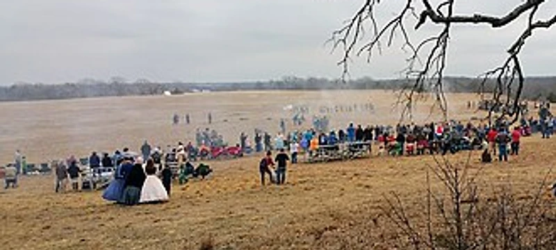
Battle of Round Mountain Marker Area
Yale, Oklahoma· Payne County· Frontier Country
Marker country tied to Opothleyahola's first 1861 Civil War battle.
Love exploring Oklahoma?
Shop the OkieX merch — tees, stickers and road-trip gear made for people who take the long way home.
OkieX 1907 Heritage Tee
$23.00 – $31.00
Destination Guide
BATTLE OF ROUND MOUNTAIN – OKLAHOMA'S FIRST CIVIL WAR BATTLE
November 19, 1861 | Indian Territory | Near Keystone Lake and Yale, Oklahoma
WHERE OKLAHOMA'S CIVIL WAR BEGAN
On November 19, 1861, the American Civil War reached Indian Territory in a confrontation that would forever change the lives of thousands of Native Americans. The Battle of Round Mountain was the first recognized Civil War battle fought in what is now Oklahoma, pitting Confederate soldiers and their Native American allies against a determined coalition of Union-loyal Native Americans led by the respected Muscogee (Creek) leader Opothleyahola.
Unlike many Civil War engagements, Round Mountain was not simply a struggle between Northern and Southern armies. It was a conflict that divided tribal nations, separated families, and forced Indigenous communities to make difficult choices about their survival.
The battle also marked the beginning of a desperate journey that would eventually send thousands of Native American refugees fleeing north toward Kansas in the dead of winter.
Today, historical markers near Keystone Lake and Yale commemorate the engagement, although historians continue to debate exactly where the fighting occurred.
A NATION DIVIDED
When the Civil War erupted in April 1861, Indian Territory occupied a precarious position between the Union and Confederacy.
The Five Tribes—the Cherokee, Chickasaw, Choctaw, Muscogee (Creek), and Seminole nations—had already endured decades of broken treaties, forced removal, and displacement from their ancestral homelands.
Now they faced another crisis.
As Confederate influence spread into Indian Territory and federal troops withdrew from nearby military posts, tribal leaders were pressured to choose sides. Several tribal governments entered into treaties with the Confederacy, hoping to preserve their sovereignty and protect their lands.
But those decisions were far from unanimous.
Many Native Americans remained loyal to the United States, opposed slavery, distrusted Confederate promises, or simply wanted to avoid becoming involved in another war.
Among the most prominent opponents of Confederate alignment was Opothleyahola, an elderly and influential Muscogee leader who had witnessed decades of upheaval.
Rather than submit to Confederate authority, he gathered a growing coalition of Union-loyal Muscogee, Seminole, and other Native American families.
Their movement was more than a military force. It was an entire community on the move, including women, children, elderly people, livestock, wagons, and household possessions.
Their goal was to escape the conflict and eventually reach safety under Union protection.
THE CONFEDERATE PURSUIT
Confederate authorities viewed Opothleyahola's growing movement as a threat to their control of Indian Territory.
Colonel Douglas H. Cooper, a former federal Indian agent who had joined the Confederacy, assembled a mounted force of approximately 1,300 to 1,400 men to confront the Union-loyal coalition.
His command included Texas cavalry, Choctaw and Chickasaw mounted riflemen, and Confederate-aligned Muscogee and Seminole warriors.
This was one of the most tragic aspects of the campaign: Native Americans were fighting other Native Americans, sometimes from the same tribal nations.
Cooper's troops advanced northward in November 1861, following reports of Opothleyahola's movements.
By November 19, the Confederates had located signs of the fleeing coalition near the Red Fork of the Arkansas River, now known as the Cimarron River.
They soon discovered that Opothleyahola's followers were not willing to surrender without a fight.
NOVEMBER 19, 1861: THE BATTLE BEGINS
The confrontation began when Confederate cavalry encountered Native American scouts and warriors operating ahead of Opothleyahola's main body.
As Confederate horsemen pursued the opposing scouts, they advanced into an area of timber and uneven terrain where Union-loyal warriors had taken defensive positions.
The pursuing Confederates suddenly came under heavy gunfire.
Caught off guard, the Confederate advance force withdrew toward its main body as Opothleyahola's warriors pressed their advantage.
The engagement quickly developed into a series of sharp exchanges involving mounted troops and fighters using the natural cover of the landscape.
As daylight faded, Confederate reinforcements arrived, and the opposing forces exchanged additional fire.
Accounts describe a prairie fire that threatened the battlefield and helped bring the fighting to an end.
Under cover of darkness, Opothleyahola's followers withdrew northward, continuing their effort to escape Confederate forces.
Colonel Cooper subsequently claimed victory because his opponents had abandoned the area.
Yet the outcome was more complicated than a simple Confederate triumph. Opothleyahola's warriors had successfully resisted the Confederate advance and enabled their people to continue their journey.
The precise number of casualties remains uncertain, with conflicting reports from participants.
A VICTORY THAT FAILED TO END THE RESISTANCE
Although Confederate commanders declared Round Mountain a victory, they had not destroyed Opothleyahola's coalition.
Thousands of Native American civilians remained on the move, still hoping to reach Union-controlled territory.
The Confederate pursuit continued.
On December 9, 1861, the opposing forces fought again at the Battle of Chusto-Talasah, also known as Caving Banks, near Bird Creek in present-day northeastern Oklahoma.
The conflict culminated on December 26 at the Battle of Chustenahlah, where Confederate forces attacked Opothleyahola's followers in rugged terrain.
The resulting defeat scattered the Union-loyal coalition and forced many survivors to flee toward Kansas.
THE DEVASTATING FLIGHT TO KANSAS
The aftermath of the campaign was one of the great humanitarian tragedies of the Civil War in Indian Territory.
Thousands of Native American refugees, including women, children, and elderly people, struggled northward through freezing winter conditions.
Many had abandoned their homes, livestock, food supplies, and possessions.
Refugees faced hunger, exposure, illness, and inadequate shelter. Many died during the journey or in the refugee camps that followed.
The ordeal became part of a larger pattern of wartime displacement that devastated communities throughout Indian Territory.
For Opothleyahola's followers, the campaign had never been simply about winning a battlefield engagement. It was a struggle to preserve their families, their independence, and their ability to choose their own future.
Some of the surviving Union-loyal Native American men later served in federal Indian Home Guard regiments, returning to Indian Territory as Union soldiers.
THE MYSTERY OF ROUND MOUNTAIN'S LOCATION
One of the most fascinating aspects of the Battle of Round Mountain is that historians still disagree about precisely where it occurred.
For many years, the battlefield was associated with the former community of Keystone, near the confluence of the Arkansas and Cimarron rivers west of Tulsa.
Historical markers in the Keystone Lake area commemorate this interpretation.
However, researchers including noted Oklahoma historian Angie Debo presented evidence supporting an alternative location several miles west of Yale, in Payne County.
That location is associated with two prominent elevations known as Twin Mounds, giving rise to the alternate name Battle of Round Mountains.
Both locations have historical markers, and both interpretations have supporters.
The construction of Keystone Lake in the 1960s further complicated research into the Keystone-area theory by flooding portions of the historic landscape.
Despite decades of investigation, the precise battlefield location remains unsettled.
This enduring mystery makes Round Mountain unusual among Oklahoma's Civil War sites: the battle is well documented, but the precise ground where it was fought remains uncertain.
VISITING THE HISTORICAL MARKERS
Visitors interested in exploring the Battle of Round Mountain can discover two different commemorative locations.
Keystone Lake Area – Tulsa County
A historical marker near State Highway 51 and Tower Road, east of Mannford, commemorates the Battle of Round Mountain and the 1861 confrontation between Confederate forces and Opothleyahola's followers.
The surrounding countryside offers an opportunity to consider how the area's rivers, timber, and rolling terrain shaped military movements during the campaign.
Modern Keystone Lake has dramatically altered the landscape since the Civil War.
Yale Area – Payne County
Another historical marker on McElroy Road, approximately four miles west of Yale, identifies the alternate proposed battlefield location.
This interpretation places the fighting near the Twin Mounds and Salt Creek area.
Visitors can experience a more rural landscape and gain an appreciation for the geography that influenced historians investigating the battle.
These are commemorative markers, not definitively established battlefield boundaries. Visitors should respect private property and avoid entering unmarked land without permission.
WHY ROUND MOUNTAIN MATTERS
The Battle of Round Mountain represents a chapter of Civil War history that is often overlooked in traditional accounts of the conflict.
It reminds us that the Civil War extended far beyond the famous battlefields of Virginia, Tennessee, and Pennsylvania.
In Indian Territory, the conflict involved questions of tribal sovereignty, political allegiance, survival, and the consequences of federal and Confederate policies toward Native American nations.
Round Mountain was the opening engagement in a campaign that displaced thousands and deepened divisions within tribal communities.
It also demonstrated the determination of Opothleyahola and his followers to resist Confederate control, even when the odds were against them.
More than 160 years later, the historical markers stand as reminders of the people whose difficult choices and sacrifices shaped Oklahoma's history.
PLAN YOUR VISIT
Historical significance: First recognized Civil War battle in Indian Territory
Date of battle: November 19, 1861
Principal commanders: Opothleyahola (Union-loyal Native American coalition) and Colonel Douglas H. Cooper (Confederacy)
Outcome: Confederate victory in official classifications, although Opothleyahola's forces successfully withdrew
Location: Disputed between the Keystone Lake area and the Twin Mounds area west of Yale
What to expect: Roadside historical markers, rural scenery, and opportunities to explore the history of Oklahoma's Civil War era
Suggested nearby destinations: Keystone State Park, Keystone Ancient Forest, and other historic locations in the Arkansas and Cimarron river valleys
Visitor tip: Combine a stop at the Round Mountain historical marker with a scenic drive through the Keystone Lake region. For visitors especially interested in Civil War history, consider exploring both marker locations to better understand the longstanding historical debate.
DISCOVER OKLAHOMA'S OVERLOOKED HISTORY
The Battle of Round Mountain is more than the story of a forgotten Civil War engagement. It is the story of Native American families caught between competing powers, a leader determined to protect his people, and a struggle whose consequences extended far beyond the battlefield.
The exact location may remain a mystery, but the significance of what happened on November 19, 1861, is undeniable.
Explore more of Oklahoma's remarkable history with Okie Explorers.
Location & Contact
OK-51 east of Yale, Yale, Oklahoma 74085.0
Hours, pricing, and availability may change. We recommend confirming details directly with the destination before traveling.